| Name | Last modified | Size | Description | |
|---|---|---|---|---|
| Parent Directory | - | |||
| ASCII_Ground_Points/ | 2016-08-01 17:44 | - | ||
| All-Return_Point_Clo..> | 2016-08-01 14:56 | - | ||
| Bare_earth_tifs/ | 2016-08-01 15:22 | - | ||
| Boundary/ | 2016-08-12 15:45 | - | ||
| First_Return_tifs/ | 2016-08-01 15:22 | - | ||
| Ground_Point_Cloud_c..> | 2016-07-28 15:29 | 62K | ||
| Ground_Point_Cloud_laz/ | 2016-08-01 14:59 | - | ||
| Index/ | 2016-08-12 15:45 | - | ||
| Intensity_Images/ | 2016-08-02 13:23 | - | ||
| Intensity_tifs/ | 2016-08-02 15:37 | - | ||
| Metadata/ | 2016-07-23 07:57 | - | ||
| Reports/ | 2016-08-08 16:08 | - | ||
| Trajectories/ | 2016-07-23 08:23 | - | ||
| colville.mxd | 2016-08-08 14:28 | 1.7M | ||
| colvilleNF.mxd | 2016-07-27 11:46 | 876K | ||
| colvilleb.mxd | 2016-08-12 15:45 | 1.4M | ||
| intensity/ | 2016-07-23 07:24 | - | ||
| mosaics/ | 2016-08-12 15:45 | - | ||
| shrinkage.txt | 2016-08-12 15:57 | 1.6K | ||
| tessfile | 2016-08-01 18:04 | 28M | ||
| tmpgrids/ | 2016-08-12 15:45 | - | ||
| tmptifs/ | 2016-08-03 15:07 | - | ||
| txt_and_las_files_fo..> | 2016-08-01 14:02 | - | ||
| who_wants_uncompress..> | 2016-08-10 12:34 | - | ||
| whyfull20160725 | 2016-07-25 13:39 | 351 | ||
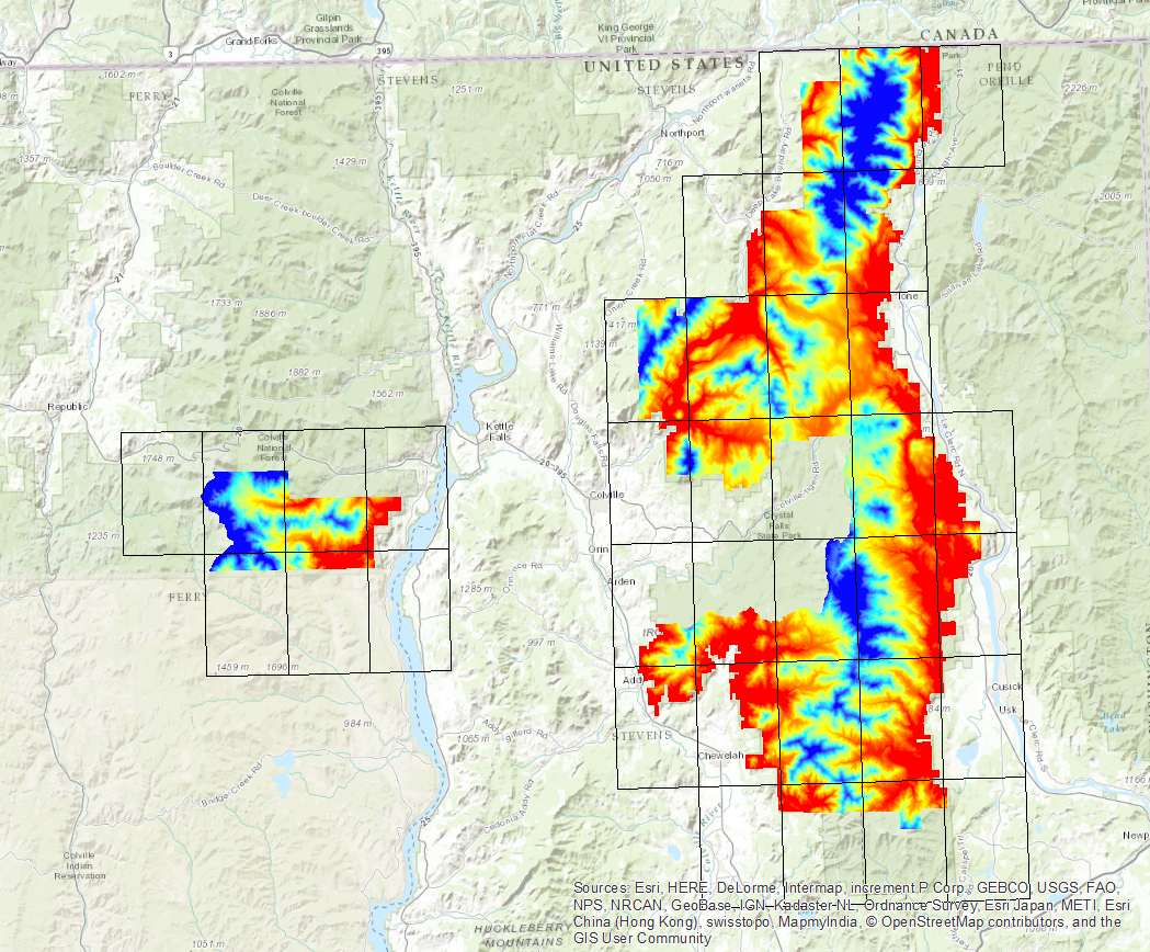
The Colville National Forest is in northeast Washington State.
This data was uploaded to our server July 24, 2016 and posted online July 27. We are still in the process of converting las files to laz format, and mosaicking and documenting. The image shows the 7.5-minute quads. These boxes are one-eighth of a degree on a side. They are disctinctly rectangular at this latitude, and appear tilted in the NAD_1983_StatePlane_Washington_South_FIPS_4602_Feet coordinate sytem.
| bytes | link | comment |
|---|---|---|
| Index polygon shapefiles include: | ||
| 26503 | Col_2015_Lidar.zip | Project boundary |
| 41936 | Project_Boundary_Quads.zip | 7.5' quads clipped to bounds |
| 42225 | Project_Boundary_Quads_mtos.zip | 7.5' quads clipped to bounds (huh) |
| 15132 | Colville_7_5_Quads.zip | 7.5-minute quads |
| 170152 | Colville_100th_Quads.zip | Tiles for point files |
| More_downloads | ||
| [dir] | All-Return_Point_Cloud_laz | .laz files |
| [dir] | Ground_Point_Cloud_laz | Just ground returns |
| [dir] | ASCII_Ground_Points | XYZ only |
| [dir] | Bare_earth_tifs | 32-bit geotiffs of 7.5' quads |
| [dir] | First_Return_tifs | same, but treetops |
| [dir] | Intensity_tifs | |
| [dir] | Metadata | .xml files |
| [dir] | mosaics | under construction |
| [dir] | Reports | PDF files |
| [dir] | Trajectories | ASCII flightlines |
| Does anybody really want these? | ||
| [dir] | Intensity_Images | uncompressed imagine files |
| [dir] | txt_and_las_files_for_people_who_do_not_appreciate_laz_files | |
| [dir] | who_wants_uncompressed_imagine_files | |